FLUTUATUONS IN GROUNDWATER LEVEL
Introduction: Any phenomenon, which produces pressure change
within an aquifer, results into the change of ground water level. These changes
in ground water level can be a result of changes in storage, amount of
discharge and recharge, variation of stream stages and evaporation. External
loads such as tides, trains, atmospheric pressure and earthquake are born in
part by the ground water of confined aquifers. Hence they affect peizometric
levels. The general consideration is that due to any reason if the aquifer
pressure rises above the atmospheric pressure an upleveling in ground water
level results and vice- versa. There are two broad kinds of level variation.
Secular variation: These
are variations in ground water level extending over a period of years.
Alternating seasons of wet and dry years is which the rainfall in above and
below the mean respectively, produce long period fluctuation of level. Recharge
is the governing factor, which depends upon the rainfall intensity and
distribution and amount of surface run off. In over developed basins where
draft exceeds recharge, a down ward trend of ground water level may continue
for many years.
Seasonal variation: These results from influence such as recharge from
rainfall and irrigation and discharge by pumping which follow well defined
seasonal cycles. Highest levels occur about April and lowest about September
marking the beginning and end of the irrigation seasons.
There are several factors, which claim the ground
water level to change. These are as follows.
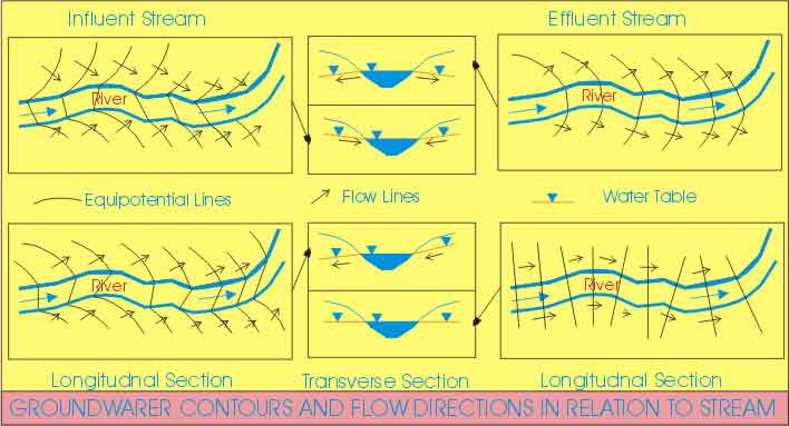
Due to stream flow: Where
a stream channel is in indirect contact with an unconfined aquifer the stream
may recharge the ground water, or receive discharge from the ground water
(termed as influent and effluent
streams respectively streams respectively depending on the relative water
levels. During a period of flood, ground water levels one temporarily raised near
the channel by the inflow of stream.
Due to evapotranspiration: In areas where the ground water level is very near
to the surface, evaporation plays a dominant role in reducing the ground water
level. Laboratory experiments have shown that if ground water level is in the
range of one foot below the
surface the highest rate of evaporation occurs and the ground water level
reduces to 3 to 4 feet, after that certain limit the effect of evaporation does
not occur literally.
Reduction in ground water level due to transpiration
occurs where the root zones of plants are directly in contact with saturated
water zone. This also results in reducing the ground water level. But in
ploughed areas and areas where no vegetation is there the effect of
transpiration in negligible. Hot windy days produce more draw down that cold
cloudy day as in the later case effect of evaporation in negligible.
Transpiration discharge does not occur also where the ground water level is
below the root zone of plants
The maximum water table level occurs in midmorning
(figure) and represents a temporary equilibrium between discharge
and recharge from surrounding ground water. From then till early evening losses
exceed recharge and the level falls. The steep slopes near midday indicate
maximum discharge associated with highest temperature. The evening minimum
again represents the equilibrium point, while the rise during the night hours
is recharge in excess of discharge.
White suggested method of computing the total quantity of ground water
with drawn by evapotraspiration during a day. Assuming that evapotraspiration
is negligible during midnight to 4 A.M., then the hourly recharge from midnight
to 4 A.M. may be taken as the average rate for the day. Letting ‘h’ equal the
hourly rate of rise of water table from midnight to 4 AM as shown in the
figure, ‘s’ is the net fall or rise of water table during 24 hrs, then as a
good approximation of diurnal volume of the ground water discharge per unit
area.
VET = Sy (24 h + s), Where Sy is specific yield near the water
table.
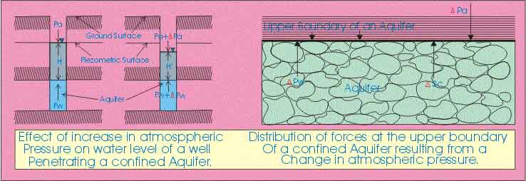
Due to atmospheric pressure: A change in atmospheric pressure is inversely
proportional to water table level in confined aquifers. When atmospheric
pressure changes expressed in terms of a column of water, the ratio of water
level change to pressure change expresses the barometric efficiency of an
aquifer. Most observations yield values in the range of 20 to 75 %. The
explanation of the phenomenon can be given by assuming that aquifers one elastic
body.
If ‘+Pa’ is the change in atmospheric pressure and ‘+Pw’ is the
change in hydrostatic pressure at the top of a confined aquifer then,
+Pa = +Pw
+ +sc ----- (i) , Where +sc is the
increased compressive stress on the aquifer.
At a well penetrating the confined aquifer the
relation (i) becomes’
Pw = Pa + lgH ----------
(ii), Where ‘g’
is the specific weight of water. Let the atmospheric pressure increase by +Pa then-
Pw + +Pw = Pa + +Pa
+ lH¢
-------------- (iii)
As shown in figure,
Substituting for Pw from equation (ii) yields
Pw = Pa + l (H¢ –
H) ---- (iv)
It is apparent that +Pw < +Pa indicating that H¢ < H. Generally therefore, the water level in a
well falls with an increase in atmospheric pressure. For an unconfined aquifer
atmospheric pressure changes are directly transmitted to the water table in the
aquifer and a well, hence no fluctuation results.
Due to wind: Minor
fluctuation of water levels is caused by wind blowing over the top of wells.
The effect is identical to the action of a vacuum pump. As a gust of wind blows
over the top of a casing, the air pressure within the well is suddenly lowered
and consequently the water level rises. After the gust parries the air pressure
in the well rises and water level falls.
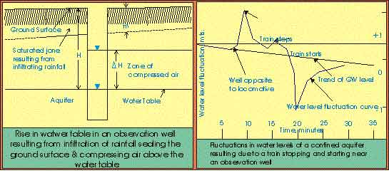
Due to rainfall: Annual ground water level fluctuation results from
seasonal variation of recharge from rainfall.
Due to ocean tides: In
coastal aquifers in contact with the ocean fluctuation of ground water level occurs
in response to tides. If the sea level varies with simple harmonic motion, a
train of sinusoidal waves is propagated inland from the submarine outcrop of
the aquifer. With distance, inland amplitude of the waves decreases and the
time lag of a given maximal increases.
Due to Earth tides: Regular semidiurnal fluctuation occuring in
small magnitude located a great distance from oceans has been attributed to
earth tides; resulting from the attraction exerted on the earth’s crust by moon
and to a lesser extent by sun. At times of new and full moon the tide producing
forces of the moon and sun act in the same direction, then the ocean tides play
a greater than average range. But when the moon is in the first and third
quarter, tide-producing forces of the sun and moon act perpendicular to one
another, causing ocean tides of smaller average range.
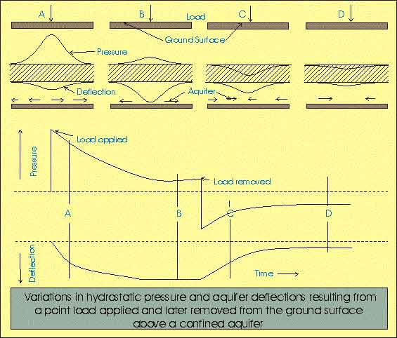
Due to external load: The elastic properties of an aquifer (confined)
result in changes in hydrostatic pressure when changes in loading occur. Some
of the best examples are exhibited by wells located hear railroads where passing trains produce
measurable fluctuation of piezometric surface.
Due to Earthquakes: Observations
reveals that earthquakes have a variety of effects on ground water. Most
spectacular are sudden rises and falls of ground water levels in wells, changes
in discharge of springs, appearance of new springs and eruption of water and
mud out of the ground. Earthquakes produce small fluctuations in the wells
penetrating confined aquifers. The earthquake waves travels at speeds of
approximately 125 miles\minute so that the fluctuations appear after little
more than one hour even from the most distant earthquakes.
Drains are proved useful in controlling the ground water levels. Drains are
designed in several ways. Some are composed of coarse sand gravel so that their
permeability is higher than the surrounding porous media.
Drains have many applications. An earth dam usually
contains a drain near its toe to prevent saturation of downstream face. Most
foundation of structure contains drain around their perimeter to reduce
hydrostatic pressure of water entrance. Modern highways often contain sub
drains to avoid saturation of the high way grade. On agricultural lands,
adequate drainage system is essential for stabilizing water tables below the
root zone. High water levels may result naturally in flat lands, bordering
rivers, lakes or the oceans. To regulate water levels within narrow limits over
a large area, drains are laid in parallel lines at depths and spacing governed
by local crop and soil conditions.
Pumping wells also may control water levels; the process being
identical to wells providing water supplies. Well
points, are lines of small diameter wells most often installed for
dewatering surface construction site. Relief wells
are placed near the toes of dams and levee’s to lower water table there by
reducing uplift pressure produced by seepages under the structures.