SOME INDIAN EXAMPLES

NAGARJUNSAGAR DAM

The 
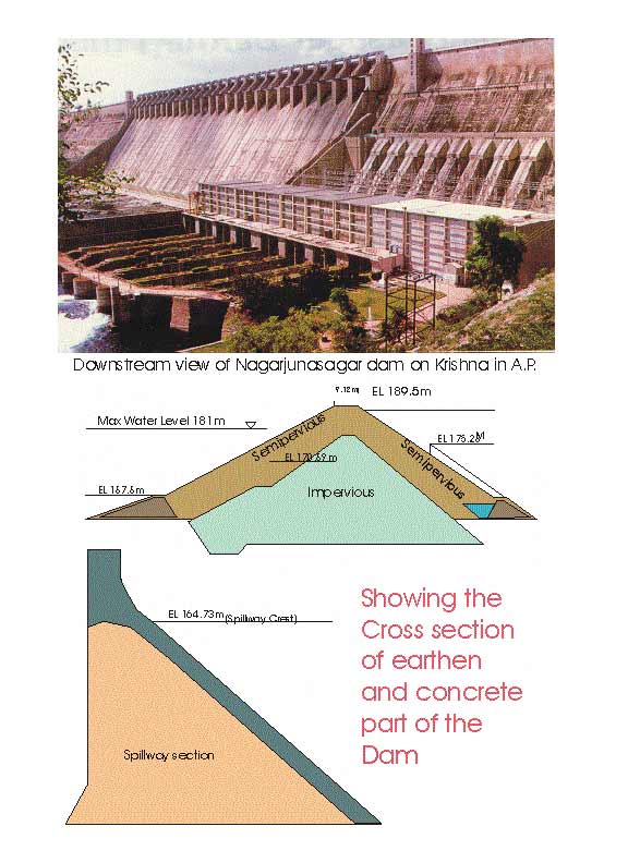
Nagarjunsagar is located near Nandikonda village of district Nalgonda in  Andhra Pradesh.  The main dam in located at latitude 160 34' 23"N and longitude 790 18' 47"E.  It is an earth cum gravity dam and has been dubbed as the giant among the Indian masonry dams. The height of the dam in 125m and cumulative length of the crest is 4,865m.  Out of this the earthen part makes 3.415m, masonry part 978m (both non overflow sections) and the spillway section being 472m.  The dam consumed 5,610,000M3 of concrete and masonry as well as 2,350,000M2 of earth.  It has been built on river Krishna for serving the purpose of irrigation and hydropower.  The Ogee type spillway has 26 redial gates each measuring 13.72X13.41m with a maximum discharge capacity of 53,540m3/s.  The reservoir area is 285 km2 with its gross storage and effective storage capacities being 11,550,000,000m3 and 6,990,000,000m3 respectively.  The available draw down is 24.38m.  The catchment area is 2,15,192km2 with a mean annual runoff of 42,360,000,000m3.  The catchtment area receives an annual rainfall of 89 cm.  The power plant is conventional Fransis vertical types with a generation capacity of 700MW.  The construction of the dam started in 1957 and it was commissioned in 1974.  Figure 1 shows an image of the dam with X-section of earthen and concrete parts.

Geology

River Krishna here passes through a forest region and bedrock are made up of Archaean granite – gneiss.  These rocks are free from unwanted joints and fissures.  The foliation also is not district.  These rocks are overlain by gently dipping quartzite.  Hence, the foundation rocks are very sound.  The right abutment slopes are steep whereas the left bank slopes are gentle to moderate.  On the left abutment the weathering in granites underlying the sediments is very variable; there is a sudden drop in level of the granite – sedimentary rocks contact just upstream of the dam axis and a band of breccias and an adjacent dyke enter into the left abutment very near the dam axis.

Foundation Treatment

1.                  In the river bed portion where granite rock is met with in the foundations, the following treatment has been imparted:

(i)                 Consolidation grouting at low pressures to shallow depths to improve upon the bearing surface of the dam foundations;

(ii)               Curtain grouting at high pressures in deep holes to form a water-tight curtain and cut-off percolation in the foundation rocks up to a depth of 30.48m to 45.72m; and

(iii)             Provision of drainage holes, in rear of the grout curtain to take out any water that may find its way beyond the grout curtain and thus reduce the uplift on the base of the dam.

2.                  In the flanks where the dam is founded on quartzite rocks, more extensive drilling and grouting was carried out for the foundations, as indicated below:

(i)                  Consolidation grouting at low pressures was done in these foundations with holes put for the whole width and length of the foundation area at intervals of 6.10m at 7.62 m;

(ii)                Blanket grouting of the rock upstream of the dam for a width of 15.24m to 30.48m in the same manner as for consolidation grouting;

(iii)              Deep hole curtain grouting later on from the foundation gallery but with reduced pressures in the quartzite rocks;

(iv)               Drainage holes in rear of the grout curtain in the same manner as for the granite rocks in the river bed portion;

(v)                 Special treatment to the abutting rocks on either flank, where the foundation grade changes abruptly, which consists mainly of quartzites and shales, by drilling and grouting at different levels with radial holes before the dam masonry was built and through shafts and adits left in the body of the dam later on, after the masonry was built; and

(vi)               A series of deep holes, extending up to granite rock below, were drilled and grouted in the front portion of the abutting hills for a distance of 15.24 m from the front face of dam.  These holes were put in concentric rings of 7.62m, 15.24m and 22.86m radius to seal off the foundations at the location where the foundation grade changes abruptly.

3. Consolidation Grouting: In this pattern of grouting, holes were drilled to shallow depths and grouted under pressures ranging from 2.81 to 3.52 kg/cm2 (40 to 50psi) in quartzites and 5.27 to 7.03 kg/cm2 (75 to 100psi) in granites for general consolidation of the foundation.  This was mostly done with wagon drills, i.e., non-coring types percussion drills, with 5.08 to 6.35 cm (2 to 2½ in.) bits.  In granite rock, 4 to 5 rows of holes were drilled parallel to the axis of the dam at 6.10 m (intervals in each row and staggered and normal to the surface, except where it was required to intercept joints in the rock.  In quartzite rocks, the holes were put for the full width and length of the dam and, where joints or weak portions were encountered, additional holes were put in and grouted. The grout used was made thicker or thinner according to the nature of the joints and seams grouted. Generally cement water grout proportions varying from 1:3 to 1:10 were used. Test holes were drilled and grouted later on to see if the grouting done earlier has filled up all the seams and joints of less depth and in fairly good rocks where the joints are not wide and where the foundation rock need not be grouted joint after joint under varying pressures. Stage grouting was done where it was necessary to grout seam-by-seam or zone-by-zone.

4. High Pressure Grouting

For this pattern of grouting, one row of the deep holes of 30.48m to 45.72m depth were drilled at closer intervals of 3.05 m along a line parallel to the axis of dam and close to the heel and grouted under high pressures of 17.58 to 21.09 kg/cm2 (250 to 3000psi) This drilling and grouting was carried out, through the foundation gallery provided in the dam close to the heel just at a little height above the foundation rock, after the dam masonry was raised to sufficient heights of 30.48 to 45.72 m above foundations, to see that the top layers of foundation rock do not get disturbed due to the high grout pressures used in the process of grouting.  These grout holes were drilled, through 7.62cm diameter pipes embedded in the dam masonry below the foundation gallery, with a slight inclination towards the heel of the dam.  This drilling was done with diamond drills of rotary type in order to prevent disturbance to the foundation rock.  The grout holes were of 3.52 cm minimum diameter and were drilled with AX and EX diamond bits by means of Joy Electric Drills No. 7. For grouting under pressures up to 21.09 kg/cm2 (300psi), double acting type Gardner Denver pumps run by compressed air were used.

BHAKRA DAM

This the prime project of India, called Bhakra-Nangal Project was constructed on Sutlej river for irrigation and power supply.  It has been named after village Bhakra. The dam is 225.6m high (the highest in India so far).  The dam has two power house with a combined generation of 1050 MW.  The dam was completed in all respect by 1963.


Geology

The dam is situated in the outer foothills of Himalayas, known as Siwalik Hills.  The foundation rocks are chiefly made up of Siwalik formation, the rock units being sandstone and clay beds with thick conglomerates forming upper part of the stratigraphic column.  The rocks are of Miocene to Pleistocene in age.


Dams of the world                Top 10 storage dams           Top 10 Hydrodams              GAP project (dam)

World commission on dams               Dam report            Risk analysis for dam safety              Dam failures

Dam failures-natural hazards          Software in dam break analysis       Engineering geol & dam links