Ever since the civilization, need to store water for
future uses has been a common practice.
Blocking a flowing stream to hold water behind it in a suitable valley
is the subject of dam building. People from the beginning of recorded history
have constructed barriers across rivers and other watercourses to store or
divert water. The earliest of these dams were used to water farms. For example,
the ancient Egyptians built earth dams that raised the river level and diverted
water into canals to irrigate fields above the river. The Moors carried
knowledge of irrigation from Egypt and Babylonia to Spain. One of the mightiest
man-made structures ever made by man in the world then is Grand Coulee Dam on
the Columbia River in Washington State. Completed in 1942 by the United States
Bureau of Reclamation, it towers 168m and is 1,272m long. All three of the
great Pyramids of Egypt could be put inside of it. The dam contains enough
concrete to build a highway across the United States and back. Behind the dam,
the waters of the Columbia River pile up to form a lake 243km long. The tallest in India, Bhakra Dam was
commissioned in 1963 with a gross reservoir capacity of 9621 million cubic
meter and a generation capacity of 1354MW. The Project has brought green
revolution along with industrial power independency to most of north India.
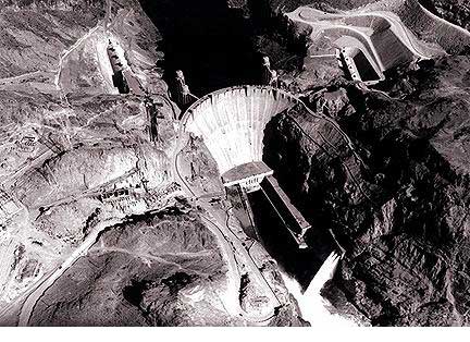
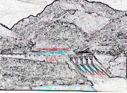
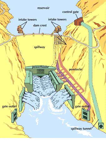
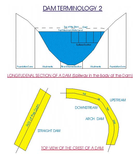
The artificial lake backed up by a dam is called a
reservoir. That part of a dam over which the floodwaters flow to the river
below the dam is the spillway. Water may pass over the crest of the dam itself,
or near the dam in chutes, tunnels, or shafts. A sluice is a passage through
the dam itself for lowering the water level of the reservoir. Pipes for
conducting water to the power turbines are called penstocks. Control gates
regulate the flow of water from intake towers through spillways, sluices, and
penstocks.
THE NEED FOR DAMS: Dams are built
primarily for irrigation, water supply, flood control, electric power, and
improvement of navigation. Many modern dams are multipurpose.
Irrigation dams store
water to equalize the water supply for crops throughout the year. Irrigation is
a primary purpose, for example, of Hoover Dam
on the Colorado River. Before the dam was built, the Colorado flooded the
Imperial Valley in California and the Yuma Valley in Arizona when the mountain
snows melted, and it became a sluggish stream in summer. Now the dam saves the floodwaters and provides a steady supply
of water for irrigation.
Dams are used for irrigation also when a river has
cut its bed below land to be irrigated. Grand Coulee Dam serves such a purpose.
A huge plateau, almost as large as Delaware, lies hundreds of feet above the
Columbia River. From the reservoir created by the dam, the world's largest
pumps lift water to another man-made lake on the plateau. From there, water
flows in canals to farms.
Some dams divert rivers into irrigation canals or
pipelines. Imperial Dam across the Colorado River is an example. It diverts
water from the river into the All-American Canal for irrigation of the Imperial
Valley in California and into the Gila Canal for irrigating the Gila Valley in
Arizona many miles away.
Therefore a dam has minimum (though plenty) two
associates namely a reservoir and a spillway and all three of them co-exist.
The
distinguishing features of a dam from other civil engineering structures are:
1.
Unusual
accumulation of large mass of construction materials on water on a limited area
of the earth's surface and hence exceedingly heavy pressure on the foundation. The
material used for Chamera I dam can be used for building 12' wide and 6"
thick road from Jammu to Kanyakumari.
2.
Destructive influence
of water in the reservoir, the foundation and on the structure which may cause
leakage/seepage, erosion or even failure of the structure, and
3.
Emplacement always in a
valley.
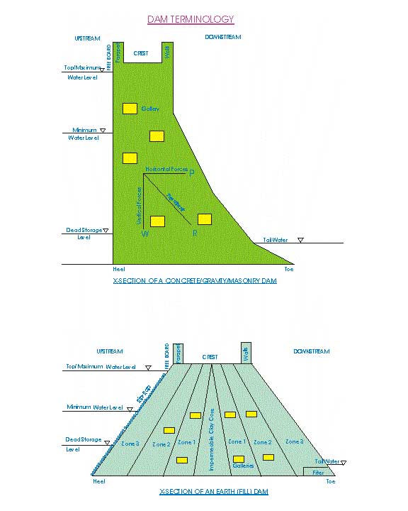
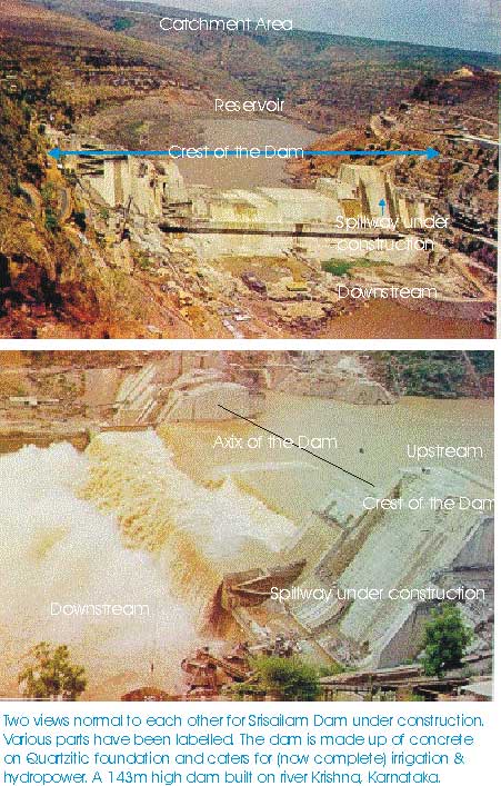
·
Reservoir: The part of catchment’s area behind (upstream) the
dam in which the water is stored.
·
Spillways:
These are controlled/uncontrolled openings in the body of the dam or somewhere
else on the reservoir periphery in order to convey the reservoir water
downstream.
·
Abutment:
The sloping sides of the valley upon which the dam rests.
·
River
or channel section: Is the
central portion of the dam that directly overlies the river channel.
·
Heel: The upstream portion of the dam where it contacts
the foundation surface.
·
Toe:
the downstream portion of the dam where it contacts the bearing surface.
·
Crest:
Is the topmost plane on the dam, sometimes used as roadways/pedestrians etc.
·
Parapet
Walls: walls along the length of
the dam on either side of crest to afford safety to a road or a walkway.
·
Axis
of the dam: An imaginary line drawn along the exact center of
the plan of the crest.
·
Dam
X-Section: Section drawn across
the axis of the dam.
·
Free
board: The distance between the
highest level of water in the reservoir and top (crest) of the dam.
·
Maximum
water level: The highest
elevation at which water can be stored in a reservoir without overtopping the
dam or being released through the spillways.
·
Minimum
water level: The lowest
elevation to which the reservoir water can be lowered and water still be drawn.
·
Dead
Storage Water Surface: The
elevation of the reservoir below, which water stays permanently in the
reservoir and cannot be drawn.
·
Tail
water: Water at the downstream
side of the dam.
·
Galleries:
These are horizontal and/or vertical openings within the body of a dam at
one/various levels to monitor seepage/leakage and other maintenance schedules.
·
Riprap:
Facing of rock fragments/gravels on the upstream slope of the dam in order to
save it from the action of reservoir waves (for earth dams only).
·
Filter:
Made up of gravely material at the toe of the dam in order to regulate the flow
within the body of the dam (for earth dams only).
·
Core:
The central portion of an earth dam made up of relatively impermeable (clay)
material to check seepage within the body of the dam (for earth dams only.
· Zones: The portion surrounding the core from both sides made up mainly of sand, silt, gravel, clay etc (depending upon availability of the construction material at/near the site). Depending upon the design, scale and local conditions the core may be surrounded by more than one zone. The permeability of the zones decreases as one approaches from faces to the core of the dam.
Dams of the world Top 10
storage dams Top 10
Hydrodams GAP project
(dam)
World
commission on dams Dam report Risk
analysis for dam safety Dam failures
Dam failures-natural hazards Software in dam break analysis Engineering geol & dam links