LANDSLIDES
Introduction
Rapid
movements of sliding rocks separated from the underlying stationary part of the
slope by a definite plane of separation are designated as landslides in the stricter
sense. A Creep is a slow and long-term deformation of slopes usually not
occurring along one distinct sliding surface but within a thick zone consisting
of a system of partial sliding planes.
Landslide study
![]()
Geological view Engineering
view
Economic significance of landslides
(a)
Single house or entire
settlement.
(b)
Agricultural and forest
lands.
(c)
The operation of
quarries and exploitation of mineral deposits.
(d)
Communication under
construction or in use.
(e)
Tunnel constructions.
(f)
Functioning of
submarine cable interrupted by subaqueous slide.
(g)
Water sewage, gas
conduits, telephones and electrical lines.
(h)
Hydro technical work
(Dam construction).
(i)
Diversion canals,
penstocks.
(j)
Reservoirs,
contributing to their silting by material slid down of their banks.
Factors Producing Slide Movements
1.
The change of slope
gradient (Natural and Artificial)
2.
The excess load by
embankments
3.
Shocks and vibrations.
4.
Changes in water
content.
(a)
Effect of
precipitation.
(b)
Electro-osmotic
process.
(c)
Desiccation &
shrinking of soils.
(d)
Abrupt changes in water
level.
5.
Effects of ground
water
(a)
Ground water flow
(b)
Solubility
(c)
Washing out of fine
sand and silt particles.
(d)
Confined aquifer
(uplift)
6.
Frost effect
7.
Weathering of rocks.
8.
Changes in the
vegetation cover of slopes.
Types of landslides (Division of sliding phenomena)
1.
Slow flowage type
Creep
![]()
Soil
Talus Rock Rock Solifluction
Scree Glacier
2.
Rapid flowage type
Flow
![]()
Landslides
![]()
![]()
Slump
Debris Debris Rock Rock Fall
3.
Subsidence: Downward displacement of superficial earth material
without a free surface & horizontal displacement.
(Corrective) Measures
A. Treatment of slope failure
4% of the slipping mass volume is displaced from the
head to the toe - stability increases 10 times [Can be started without any
research]
B. Drainage of landslides
-Surface drainage:
1. All
streams and temporary watercourses should be prevented from entering the area.
2. All
springs must be entrapped and diverted outside the slide (surface pipes can be
used)
3. Open
ditches of adequate dimensions & gradients are excavated for discharging
rainwater.
4.
Ditches encircling the head scarp area to divert the water.
5.
Leveling of ground surface - All ditches & depressions (drains)
filled
-Subsurface Drainage: (Started relatively after some research but more
effective)
1.
Vertical exploration
borings (280-300mts)
2.
Use of old existing
wells
3.
Fire brigade pumps if
water reaches surface.
4.
Drainage galleries
Advantage
(good for <200m) Disadvantage (Handlover landslide)
5.
Drainage Borings (5
times cheaper than galleries)
Disadvantage (i)
Difficult to hit water bearing beds where pressure is high
(ii)
Good only for <200mts.
6.
Drainage Trenches.
C. Stabilization of landslides by vegetation: (Good for shallow slides)
(i) Drying effect, (ii) Consolidation by network of roots
D. Relating walls & similar structures
E. Rocks Bolts

F= (WCosb + KCosa )
Tanq - KSina W sinb b = Angle of
inclination of slope a = Angle between the
bolt axis and the normal to the slip surface. q = Angle of shear
resistance along the slip surface K = Total force in the rock
bolt. W = Total weight of the slip
surface. F = Force acting on the rock bolts
F. Stabilization of slope by piles
G. Hardening of soil (electro- osmosis)
If two electrodes inserted into the soil the water
contained in the soil migrate towards cathode.
H. The break of slip surface by blasting
CLASSIFICATION OF LANDSLIDES
|
Type of
Movement |
Type of Material |
|||
|
Bedrock |
Soil |
|||
|
Falls |
Soil
fall |
|||
|
Slides Few
units |
Rotational
|
Planar |
Planar |
Rotational
|
|
Slump |
Block
glide |
Block
glide |
Block
slump |
|
|
Slides
Many units |
|
Rock
slide |
Debris
slide |
Failure
by lateral spreading |
|
All
unconsolidated |
||||
|
|
Rock
fragments |
Sand or
silt |
Mixed |
Mostly
plastic |
|
Dry |
Rock
fragment flow |
Sand
run |
Loess
flow |
|
|
Flows |
Slow
earth flow |
|||
|
Wet |
Sand or
silt flow |
Mud
flow |
||
|
Complex |
Combination of
materials or types of movement |
|||
SOME LANDSLIDE IMAGES
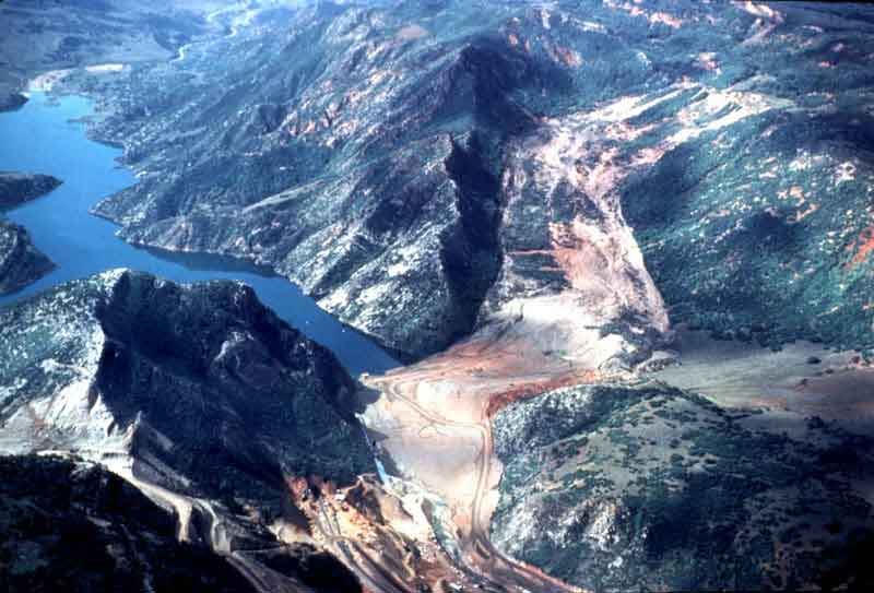
Landslide 1.-The 1983 Thistle
landslide at Thistle, Utah-This landslide began moving in the spring of 1983 in
response to groundwater buildup from heavy rains the previous September and the
melting of deep snowpack for the winter of 1982-83. Within a few weeks the
landslide dammed the Spanish Fork River, obliterating U.S. Highway 6 and the
main line of the Denver and Rio Grande Western Railroad. The town of Thistle
was inundated under the floodwaters rising behind the landslide dam. Total
costs (direct and indirect) incurred by this landslide exceeded $400 million,
the most costly single landslide event in U.S. history.
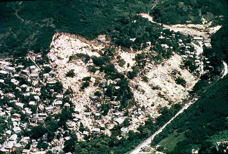
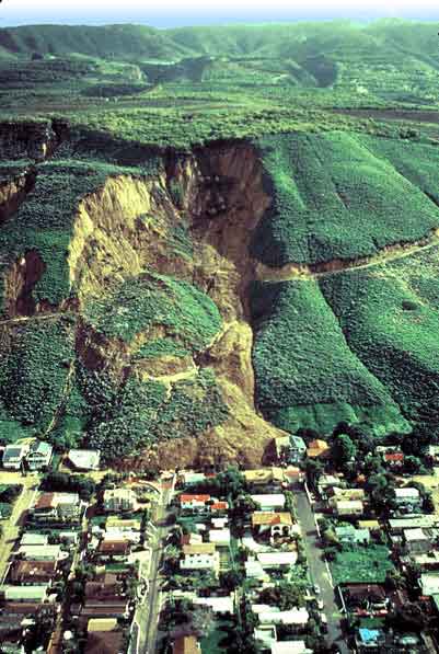
Landslide 2.-The Mamayes,
Puerto Rico, landslide, 1985. This landslide destroyed 120 houses and killed at
least 129 people, the greatest number of casualties from any single landslide
in North America. The catastrophic block slide was triggered by a tropical storm
that produced extremely heavy rainfall. Contributing factors could also have
included sewage directly discharged into the ground in the densely populated
area, and a leaking water pipe at the top of the landslide.
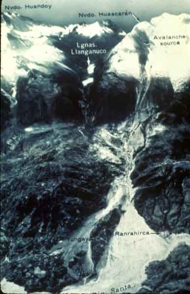
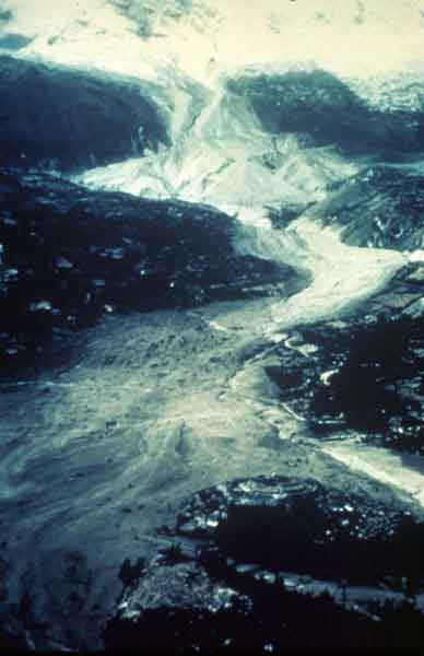
Landslide 3.-Rock and snow
avalanche, Mount Huascaran, Peru. In 1970, an earthquake-induced rock and snow
avalanche on Mt. Huascaran, Peru, buried the towns of Yungay and Ranrahirca.
The total death toll was 66,000. The avalanche started as a sliding mass of
glacial ice and rock about 3,000 feet wide and one mile long. The avalanche
swept about 11 miles to the village of Yungay at an average speed of more that
100 miles an hour. The fast-moving mass picked up glacial deposits and by the
time it reached Yungay, it is estimated to have consisted of about 80 million
cubic yards of water, mud, and rocks.
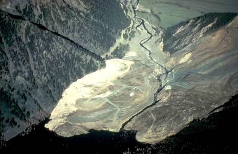
Landslide 4.- Deposits path
of the Mt. Huascaran, Peru, rock and snow avalanche.
Landslide 5.-The Madison
Canyon landslide near Yellowstone Park. This landslide occurred after the
Hebgen lake earthquake (Richter Scale Magnitude = 7.5) in Montana, in 1959. The
earthquake caused a great slide of rock, soil, and trees to fall from the steep
south wall of the Madison River Canyon. Twenty-eight people camping in the area
were killed as they were overtaken by this 21 million cubic meter mass. The
landslide formed a barrier that completely blocked the gorge and the flow of
the Madison River, and created a lake.
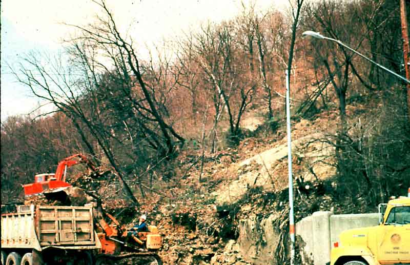
Landslide 6.- Earthflow in
Cincinnati, Ohio-This slide shows material being removed by highway crew along
the Columbia Parkway, Cincinnati, Ohio. Hamilton County, in the metropolitan
Cincinnati area, experienced an average annual economic loss of $5.80 per
person (1975 dollars) between 1973 and 1978, the highest calculated per capita
loss of any municipality in the United States.
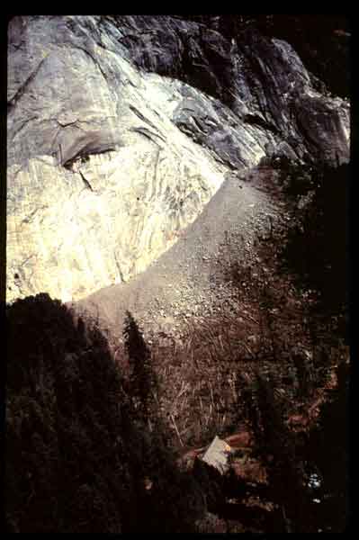
Landslide 7.- Rockfall
deposition, Yosemite National Park, California-On July 11, 1996, at 7:00 P.M.
(Pacific Daylight Time), a huge rock weighing 200 tons broke away from Granite
Point, near Happy Isles, a popular trailhead and concession stand. The rock disintegrated
when it landed, creating an air blast that was so powerful that it flattened as
many as 2,000 trees in the area. One person was killed at the concession stand,
and 14 people were seriously injured. The dust kicked up from the pulverized
granite blocked out the sun and coated tents and recreational vehicles, not
unlike ashfall from a volcano. Rockfall hazard is a continuing problem at
Yosemite, one that the U.S. Geological Survey and the National Park Service are
investigating further.
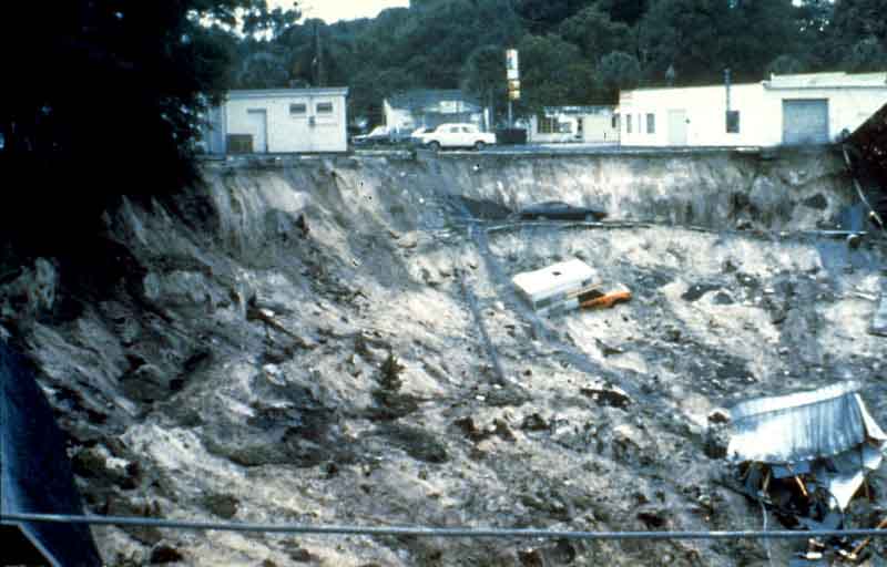
Landslide 8.- Sinkhole at
Winter Park Florida-Sinkholes, although not classified as landslides, are
another form of ground subsidence that can happen catastrophically. This
sinkhole occurred in 1981, in the time span of one day. The city of Winter Park
stabilized and sealed the sinkhole, converting it into an urban lake. This form
of subsidence occurs when carbonate layers that lie below the surface dissolve.
When the weight of the overlying ground becomes too great, or the dissolved
area too large, the surface collapses into the void. These features occur in
what is known as karst topography which is common in Florida, Kentucky,
Missouri, Pennsylvania, and Tennessee and also occurs in many other places
around the world.
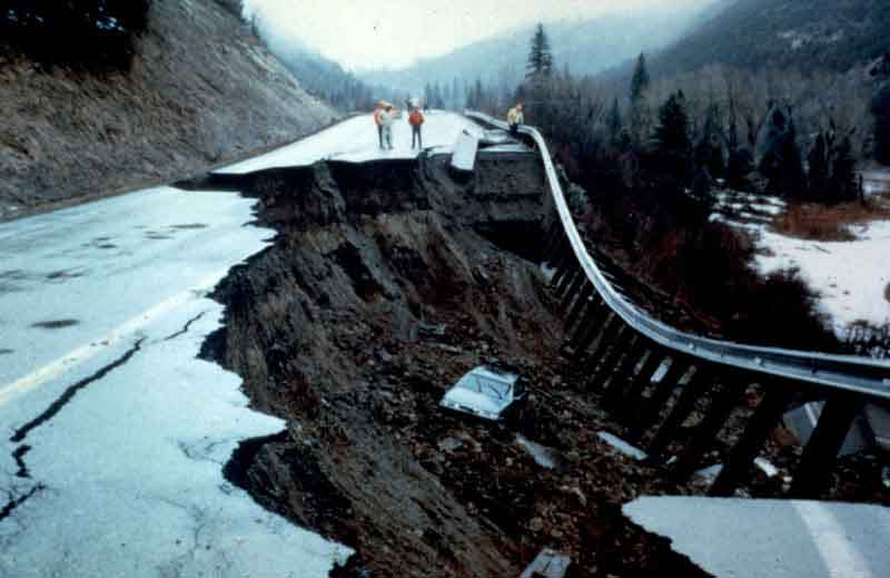
Landslide 9.- A landslide
near McClure Pass, Colorado, in 1994-This area of the Rocky Mountains has
chronic problems where roads cross landslide areas. The State has found that
the best solution in this case, is to repair the road as it becomes damaged.
This car plunged into the landslide in the middle of the night, after the
landslide occurred. Fortunately, no one was injured.
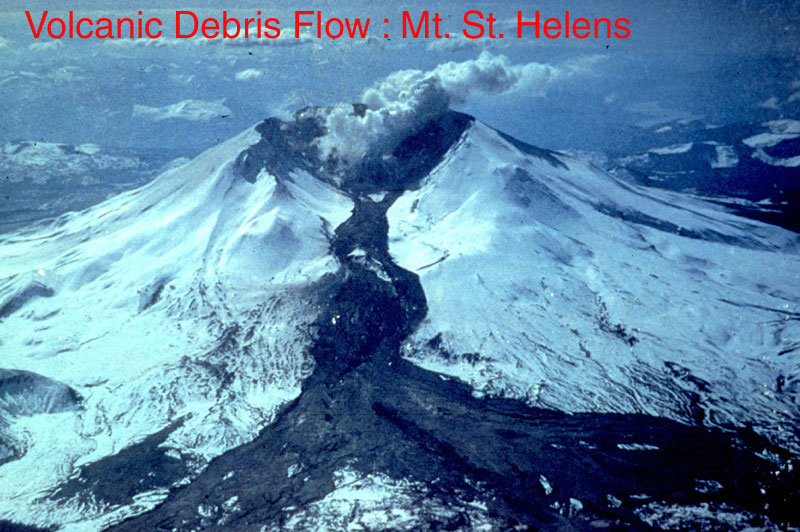
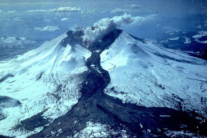
Landslide 10.- Melting snow
and ice on the north flank of Washington's Mount St. Helens, triggered this
lahar (an Indonesian term for a "volcanic debris flow"), which
rapidly traveled down the flanks of the mountain with the North Fork of the
Toutle River. The melting snow and Ice resulted from the 1982 eruption of Mount
St. Helens.
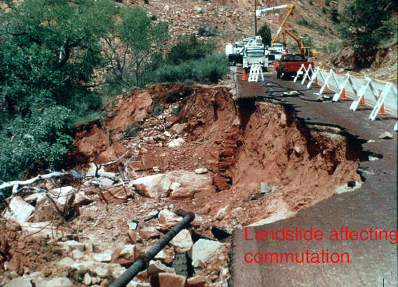
Landslide 11.- Roadcut
failure near Golden, Colorado-This small landslide on Colorado State Highway
93, a well-traveled road from Golden to Boulder, Colorado began sliding in 1993
and cost federal, state and local governments $4 million to evaluate and
remedy. Remedial measures included giant tiebacks holding the slide material
into the Precambrian bedrock, together with the construction of an elaborate
drainage system within the slide.
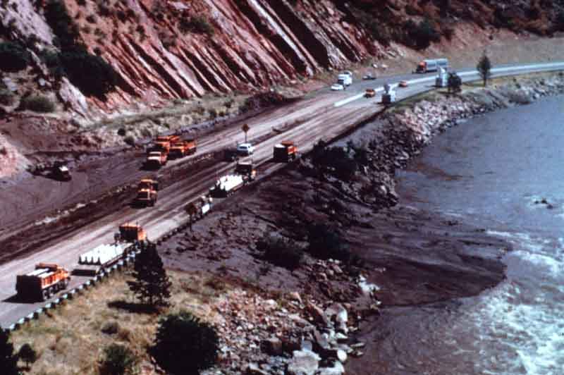
Landslide 12.- Fire-related
debris flows from Storm King Mountain, near Glenwood Springs, Colorado. The
following three photographs show the results of debris flows that blocked
Interstate-70 during Labor Day weekend, 1994. A very hot and fast-moving
wildfire in July of that year on the slopes of Storm King Mountain denuded the
slopes of vegetation. An intense rainstorm generated debris flows from material
on the burned hillslopes and in the channels between hills. Interstate traffic
was disrupted for a day and caused serious delays for emergency vehicles and
hospital access, due to the fact that Interstate-70 is the only access route
through this part of the Rockies. The Interstate-70 corridor through the Rocky
Mountains experiences numerous problems from landslides, debris flows, and
rockfalls.
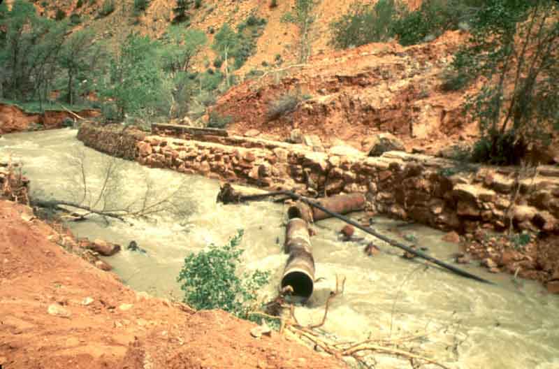
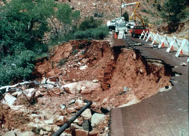
Landslide 13.- Road damage
in Zion National Park, Utah from a landslide that occurred in April, 1995. 100
people were stranded for two days in the Zion Park Lodge, because this road was
the only access to the lodge. Landslides can damage lifelines as well as block
highways, as shown by the damaged sewer line which paralleled the road.
Landslide 14.- Another view
of the Zion Park landslide.
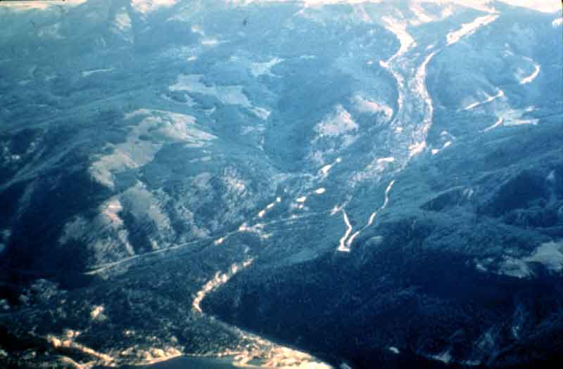
Landslide 15.- An oblique
air photo of the Slumgullion earthflow in the San Juan Mountains, near Lake
City, Colorado. This landslide which occurred about 700 years ago, is more than
7 km long, and is still moving, although very slowly. It has been continually
studied over the years by the U.S. Geological Survey and others and has
provided much technical information on landslide mechanisms.
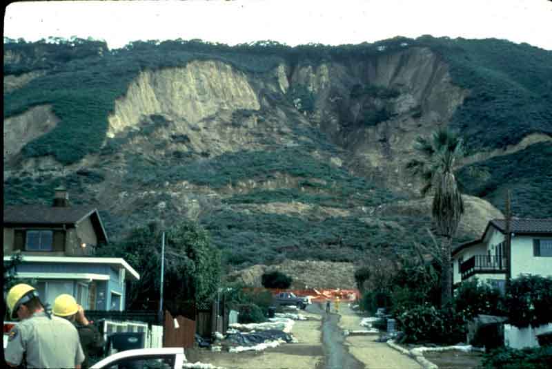
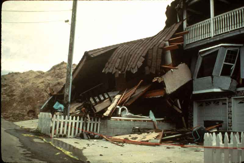
Landslide 16..- La Conchita,
California-a small seaside community along Highway 101 north of Santa Barbara.
This landslide and debris flow occurred in the spring of 1995. Many people were
evacuated because of the slide and the houses nearest the slide were completely
destroyed. Fortunately, no one was killed or injured.
Landslide 17.- La Conchita,
California, ground-level view, looking down a road, towards the toe of the
slide.
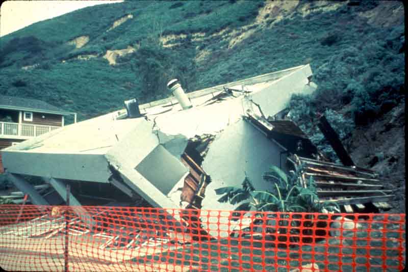
Landslide 18.- La Conchita,
California-damage to a house
Landslide 19.-- La Conchita,
California-more damage
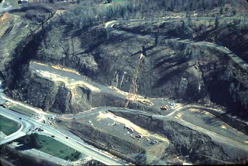
Landslide 20.- Slide 25 and
Slide 26 show effects of landslides and debris flows during the winter storms
of February 1996 in the northwestern United States. Areas of highest rainfall
intensities were centered along the Oregon-Washington border. Estimates of damage
from the floods and landslides exceeded $800 million in Washington and Oregon
alone. This slide shows a failed residential development on a hisllside at
Chehalis, Washington. Much of the failure occurred in years immediately before
1996.
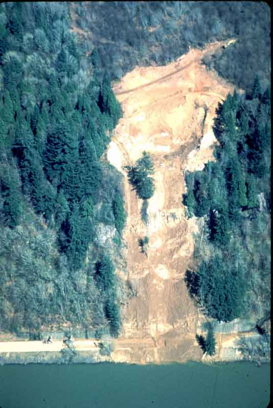
Landslide 21.- Landslide in
marine sediments over basalt, extending across Washington State Highway 4, into
the Columbia River, west of Stella, Washington.